Velletri
Velletri | Stampe | Anonimo

Velletri
Velletri | Stampe | Anonimo
Metodi di Pagamento
- PayPal
- Carta di Credito
- Bonifico Bancario
- Pubblica amministrazione
- Carta del Docente
Dettagli
- Anno di pubblicazione
- 1744
- Luogo di stampa
- ?
- Formato
- 545 X 416
- Incisori
- Anonimo
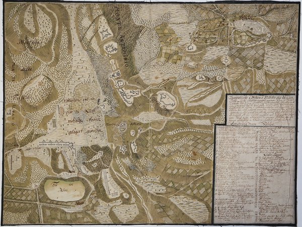
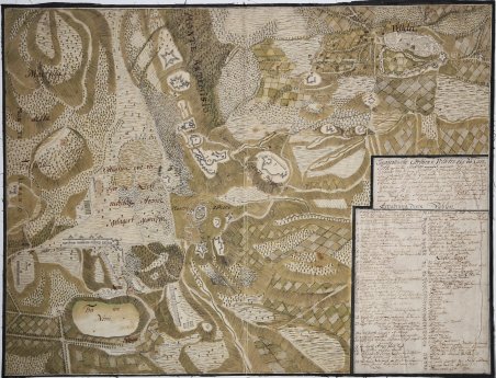
Descrizione
Carta topografica del territorio di Velletri, che mostra la situazione, tra il 29 maggio e il 1 novembre del 1744, durante la Battaglia di Velletri tra due eserciti: il napoletano-spagnolo, comandato da Sr. May e le forze austriache guidate del principe V. Lobkowiz.Sono presenti fortificazioni sia sul monte Artemisio che nella frazione de La Faiola.Disegno ad inchiostro ed acquarello su carta, applicato su tela coeva, in perfetto stato di conservazione. 'Topographical Cartes v. Velletri to Casa / Corsi, which shows the situation from 29 May to / 1 Novembr. In 1744 the two armies, the Spanish Neapolitan, under Commando Sr. May, king of both Sicilies, and the Oestreich under the command of Prince v. Lobkowiz, with special explanation as such, had been stored, and ange. Fortifications, which, as well as the other part, were erected on Mount Artemisio, as erected at Fajola, by a king. Cfr.
