New Hebrides Isl.s South West Pacific
New Hebrides Isl.s South West Pacific
Metodi di Pagamento
- PayPal
- Carta di Credito
- Bonifico Bancario
- Pubblica amministrazione
- Carta del Docente
Dettagli
- Formato
- mm 621x941
- Edizione
- '900
- Incisori
- Admiralty Charts
- Soggetto
- Vanua Lava - New Hebrides
- Disegnatori
- Admiralty Charts
- Lingue
- Italiano
Descrizione
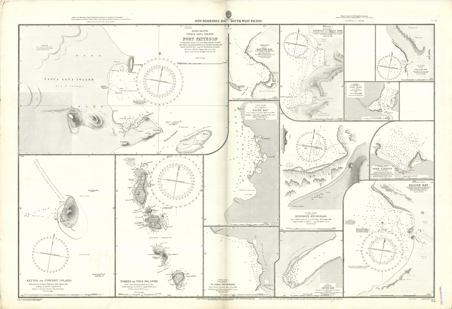
Ancient and original map of New Hebrides Isl.s South West Pacific. In the left side of the chart insert of Port Patteson, by Thomas Kerr, Master in the Ship Southern Cross 1860. with additions by Lieutenant H.P. Norwood, H.M.S. Prometheus 1911, Anuda or Cherry Island Sketch Survey by Lieutenant Wilfrid Nunn, H.M.S. Goldfinch, 1898, Torres or Vava Islands From a French Government Sketch Survey, 1895. In the right side of the chart insert of Hayter Bay, by Nav. Lieut. T.L. Mourilyan H.M.S. Basilisk 1872 Capt. J. Moresby, Espiegle and Malua Bays, by Lieut. R.N. Ommanney and Sub.Lieut. W.P. Dawson, 1882-4, Lakarere By T.C. Tilly Nav. Lieut. 1869, Port Olry by the Officers of the French ship of war "Segond"1880, Picot Bay From a French Government Sketch Survey, 1895, Ringdove Anchorage From a Sketch Survey by Lieut. W.R. Willis, H.M.S. "Ringdove" 1894, Port Narevin (Walter Bay) , Vi Paka Anchorage From a French Government Sketch Survey, 1895, Dives Bay Sketch Survey by the officers of the French Transport "laDives" 1886, Dillon Bay By T.C. Tilly, Master, H.M.S. Cordelia, 1861. London Published at the Admiralty, March 10th 1864, under the Superintendence of Capt. G.H. Richards, Hydrographer. Small corrections: 1924. Folded editorially. Autore: Admiralty Charts. Luogo: Vanua Lava - New Hebrides. Anno: '900. Tecnica: incisione. Dimensioni: 621x941 mm
Anno di pubblicazione: '900