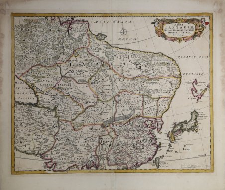
Magnae Tartariae, Magni Mogolis Imperii Iaponia et Chinae Nova Descriptio
Magnae Tartariae, Magni Mogolis Imperii Iaponia et Chinae Nova Descriptio | Stampe | WIT Frederick de
Magnae Tartariae, Magni Mogolis Imperii Iaponia et Chinae Nova Descriptio
Magnae Tartariae, Magni Mogolis Imperii Iaponia et Chinae Nova Descriptio | Stampe | WIT Frederick de
Metodi di Pagamento
- PayPal
- Carta di Credito
- Bonifico Bancario
- Pubblica amministrazione
- Carta del Docente
Dettagli
- Anno di pubblicazione
- 1680
- Luogo di stampa
- Amsterdam
- Formato
- 555 X 440
- Incisori
- WIT Frederick de
Descrizione
carta geografica raffigurante la parte settentrionale del continente, con Russia Asiatica, Cina, Giappone e Corea, tratta dal “Atlas Major”.Incisione in rame, bellissima coloritura coeva, in ottimo stato di conservazione. A beautiful example of Frederick de Wit's c. 1680 map of Tartary. The map covers from just north of the Arctic Circle to Formosa south to the the Bay of Bengal and Formosa, and from the Caspian Sea to Hokkaido or Yedso. Although parts of China, Japan, and northern India were somewhat mapped, most of northeastern Asia was fully unknown to western cartographers. The continent has here been given a curious rounded form that may be suggestive of a northeasterly route to Asia. Both the Great Wall of China and the Gobi Desert are clearly delineated. At the western edge of the map the overlarge Caspain Sea is erroneously mapped on an east-west rather than north-south axis. This map was published both independently and as part of various complied and composite atlases.Copperplate, very good condition. Cfr.
