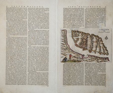
I. Ordinum Vulgo Staten Eyland
I. Ordinum Vulgo Staten Eyland | Stampe | BLAEU Johannes

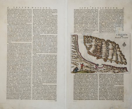
I. Ordinum Vulgo Staten Eyland
I. Ordinum Vulgo Staten Eyland | Stampe | BLAEU Johannes
Metodi di Pagamento
- PayPal
- Carta di Credito
- Bonifico Bancario
- Pubblica amministrazione
- Carta del Docente
Dettagli
- Anno di pubblicazione
- 1662
- Luogo di stampa
- Amsterdam
- Formato
- 247 X 170
- Incisori
- BLAEU Johannes
- Soggetto
- Terre Artiche
Descrizione
Rara mappa dell'isola di Vaiga? (Staten Eyland), pubblicata solo nell'Atlas Maior di Johannes Blaeu. Mostra le numerose catene montuose e un lago all'interno dell'isola; diverse baie sono notate insieme a zone di possibile ancoraggio. In basso a sinistra una scena raffigura due esploratori olandesi che vengono attaccati da un orso. La mappa è inserita all'interno di una pagina di testo latino, che continua sul verso. L'isola Vaiga? è un'isola tra il mare di Kara e il mare della Pe?ora. L’'isola si trova tra il continente e l'isola Južnyj della Novaja Zemlja. È separata dalla terraferma dallo stretto di Jugor e da Južnyj dallo stretto di Kara. These scarce maps of Vaygach Island (Staten Eyland) were only published in Johannes Blaeu's Atlas Maior. ' This map of Staten Eyland is more of a terrestrial map showing numerous mountain ranges and a lake within the island. Several bays are noted along with areas of possible anchorage. In the lower left a scene depicts two Dutch explorers being attacked by a bear. The map is displayed within a page of Latin text, which continues on the verso. Vaygach Island is an island in the Arctic Sea between the Pechora Sea and the Kara Sea. Vaygach Island is separated from the Yugorsky Peninsula in the mainland by the Yugorsky Strait and from Novaya Zemlya by the Kara Strait. Cfr.
