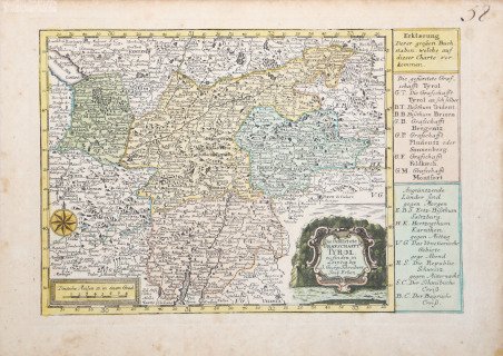
Die Gefurstate Grafshafft Tyrol.
Die Gefurstate Grafshafft Tyrol. | Stampe | SCHREIBER Johann George

Die Gefurstate Grafshafft Tyrol.
Die Gefurstate Grafshafft Tyrol. | Stampe | SCHREIBER Johann George
Metodi di Pagamento
- PayPal
- Carta di Credito
- Bonifico Bancario
- Pubblica amministrazione
- Carta del Docente
Dettagli
- Anno di pubblicazione
- 1740
- Luogo di stampa
- Lipsia
- Formato
- 260 X 180
- Incisori
- SCHREIBER Johann George
Descrizione
Tratta dall’unica opera dello Schreibern "Atlas selectus von allen Konigreichen und Landen der Welt" pubblicata a Lipsia nel 1740. Incisione in rame, coloritura coeva a mano, in ottimo stato di conservazione. Map Taken form "Atlas selectus von allen Konigreichen und Landen der Welt". This handsome little atlas includes 41 (of 42) decorative maps including a double hemisphere world, the continents, European countries, Germany with a table of distances, regional maps of Germany, the Russian Empire, the Black Sea and the Holy Land. Lacking the map of Schwabischer. The map of the Americas features the island of California. The maps include a text panel describing the region and decorative cartouches.Phillips (Atlases) #610. Cfr.
